
Passeggiate da Sueglio
passeggiata
Bellissime passeggiate da fare in gruppo, in famiglia..
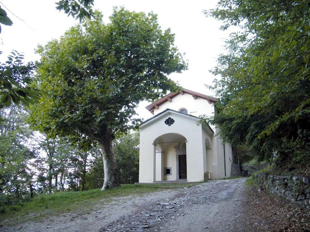
Monte Legnoncino (1714m) dai Roccoli Lorla (LC)
Lasciata l’auto nel parcheggio dei Roccoli Lorla, che si trova al termine della strada (vedi barriera) si segue la chiara indicazione (freccia gialla) e si percorre la vecchia strada militare di scarsa pendenza e con ampi scorci panoramici verso il Legnone, le Grigne e le Retiche.
In breve si arriva alla chiesetta di San Sfirio, datata 1709 ma costruita sui resti di un precedente luogo di culto, risalente almeno al 1200 con il nome del santo eremita ma sicuramente molto più antico. Subito dopo, attraverso un facile sentiero, si giunge alla cima e il panorama si apre a 360 gradi oltre il Lario fino al Monte Rosa e alle catene delle Alpi occidentali.
Se il cielo è limpido, la vista è impagabile.
Monte Legnoncino (1714m) dai Roccoli Lorla (LC)
Leave the car in the Roccoli Lorla car park, which is located at the end of the road (see barrier), follow the clear indication (yellow arrow) and follow the old military road with little slope and wide panoramic views towards the Legnone, the Grigne and the Retiche.
Soon we arrive at the small church of San Sfirio, dated 1709 but built on the remains of a previous place of worship, dating back at least to 1200 with the name of the hermit saint but certainly much older.Immediately afterwards, through an easy path, you reach the top and the panorama opens 360 degrees beyond the Lario to Monte Rosa and the chains of the western Alps.
If the sky is clear, the view is priceless

Roccoli-lorla
Monte Legnoncino (1714m) dai Roccoli Lorla (LC)
Lasciata l’auto nel parcheggio dei Roccoli Lorla, che si trova al termine della strada (vedi barriera) si segue la chiara indicazione (freccia gialla) e si percorre la vecchia strada militare di scarsa pendenza e con ampi scorci panoramici verso il Legnone, le Grigne e le Retiche.
In breve si arriva alla chiesetta di San Sfirio, datata 1709 ma costruita sui resti di un precedente luogo di culto, risalente almeno al 1200 con il nome del santo eremita ma sicuramente molto più antico. Subito dopo, attraverso un facile sentiero, si giunge alla cima e il panorama si apre a 360 gradi oltre il Lario fino al Monte Rosa e alle catene delle Alpi occidentali.
Se il cielo è limpido, la vista è impagabile.
Monte Legnoncino (1714m) dai Roccoli Lorla (LC)
Leave the car in the Roccoli Lorla car park, which is located at the end of the road (see barrier), follow the clear indication (yellow arrow) and follow the old military road with little slope and wide panoramic views towards the Legnone, the Grigne and the Retiche.
Soon we arrive at the small church of San Sfirio, dated 1709 but built on the remains of a previous place of worship, dating back at least to 1200 with the name of the hermit saint but certainly much older.Immediately afterwards, through an easy path, you reach the top and the panorama opens 360 degrees beyond the Lario to Monte Rosa and the chains of the western Alps.
If the sky is clear, the view is priceless
Santuario Madonna di Bondo
L’itinerario parte dal Centro Sportivo di Vestreno, raggiungibile in bus con la linea Dervio – Tremenico. Si imbocca la via al Bacino, carrozzabile asfaltata in ripida salita che porta al bacino di alimentazione della centrale idroelettrica di Corenno.
Qui la strada diventa pianeggiante e sterrata e poco dopo sulla sinistra si incontra una cappelletta e le sottostanti trincee e postazioni di mitragliatrice della Linea Cadorna.
Successivamente l’itinerario entra nei boschi di castagno e si raggiunge un promontorio da cui si ammira un bel panorama su Dorio e Olgiasca, da qui iniziano i pannelli della Via crucis che accompagnano i pellegrini sino al piccolo santuario della Madonna di Bondo (a.1672) dove si trova un area pic-nic.
Santuario Madonna di Bondo
The itinerary starts from the Vestreno Sports Center, reachable by bus with the Dervio - Tremenico line.Take the via al Bacino, a steep paved road that leads to the feeding basin of the Corenno hydroelectric plant.
Here the road becomes flat and unpaved and shortly after on the left there is a small chapel and the underlying trenches and machine-gun positions of the Cadorna Line.
Subsequently, the itinerary enters the chestnut woods and reaches a promontory from which you can admire a beautiful panorama of Dorio and Olgiasca, from here begin the panels of the Via crucis that accompany the pilgrims to the small sanctuary of the Madonna di Bondo (a.1672 ) where there is a picnic area.
Madonna Di Bondo
Santuario Madonna di Bondo
L’itinerario parte dal Centro Sportivo di Vestreno, raggiungibile in bus con la linea Dervio – Tremenico. Si imbocca la via al Bacino, carrozzabile asfaltata in ripida salita che porta al bacino di alimentazione della centrale idroelettrica di Corenno.
Qui la strada diventa pianeggiante e sterrata e poco dopo sulla sinistra si incontra una cappelletta e le sottostanti trincee e postazioni di mitragliatrice della Linea Cadorna.
Successivamente l’itinerario entra nei boschi di castagno e si raggiunge un promontorio da cui si ammira un bel panorama su Dorio e Olgiasca, da qui iniziano i pannelli della Via crucis che accompagnano i pellegrini sino al piccolo santuario della Madonna di Bondo (a.1672) dove si trova un area pic-nic.
Santuario Madonna di Bondo
The itinerary starts from the Vestreno Sports Center, reachable by bus with the Dervio - Tremenico line.Take the via al Bacino, a steep paved road that leads to the feeding basin of the Corenno hydroelectric plant.
Here the road becomes flat and unpaved and shortly after on the left there is a small chapel and the underlying trenches and machine-gun positions of the Cadorna Line.
Subsequently, the itinerary enters the chestnut woods and reaches a promontory from which you can admire a beautiful panorama of Dorio and Olgiasca, from here begin the panels of the Via crucis that accompany the pilgrims to the small sanctuary of the Madonna di Bondo (a.1672 ) where there is a picnic area.
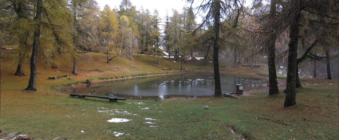
Roccoli d’Artesso (1209 m. slm).
Dal centro di Sueglio, si segue la strada che sale a sinistra subito dopo il ponte. E’ tutta asfaltata e ci sono chiare indicazioni. Nelle vicinanze di un bel laghetto circondato da larici e tavoloni per pic-nic, si possono visitare una serie di cannoniere predisposte ad ospitare grossi calibri d’artiglieria della “Linea Cadorna” nonché alcuni resti delle trincee.
Ritornando verso Sueglio sulla carrozzabile, si può far visita a Sommafiume che ha un bel bosco di larici. Al primo incrocio andare a destra.
Roccoli d’Artesso (1209 m asl).
From the center of Sueglio, follow the road that climbs to the left immediately after the bridge. It is all paved and there are clear indications. In the vicinity of a beautiful lake surrounded by larches and picnic tables, you can visit a series of gunboats designed to accommodate large artillery guns of the “Cadorna Line” as well as some remains of the trenches.
Returning to Sueglio on the road, you can visit Sommafiume which has a beautiful larch forest. At the first intersection go right.
Roccoli-lorla
Roccoli d’Artesso (1209 m. slm).
Dal centro di Sueglio, si segue la strada che sale a sinistra subito dopo il ponte. E’ tutta asfaltata e ci sono chiare indicazioni. Nelle vicinanze di un bel laghetto circondato da larici e tavoloni per pic-nic, si possono visitare una serie di cannoniere predisposte ad ospitare grossi calibri d’artiglieria della “Linea Cadorna” nonché alcuni resti delle trincee.
Ritornando verso Sueglio sulla carrozzabile, si può far visita a Sommafiume che ha un bel bosco di larici. Al primo incrocio andare a destra.
Roccoli d’Artesso (1209 m asl).
From the center of Sueglio, follow the road that climbs to the left immediately after the bridge. It is all paved and there are clear indications. In the vicinity of a beautiful lake surrounded by larches and picnic tables, you can visit a series of gunboats designed to accommodate large artillery guns of the “Cadorna Line” as well as some remains of the trenches.
Returning to Sueglio on the road, you can visit Sommafiume which has a beautiful larch forest. At the first intersection go right.
Rifugio Roccoli Lorla (Mt. 1463)
Il Rifugio si raggiunge in auto scendendo da Sueglio fino al bivo per Tremenico. All’entrata del paese ci sono sulla sinistra le indicazioni per il Rifugio Roccoli Lorla. La strada si stringe però è sempre asfaltata e con vari tornanti si giunge fino al laghetto dove finisce con un piazzale sterrato. Il Rifugio è a due passi poco dentro il bosco in leggera salita, è circondato da rigogliose faggete e splendidi lariceti che, nelle giornate autunnali, regalano all’escursionista l’intera tavolozza di colori, mentre all’inizio dell’estate sono meravigliose le fioriture di rododendri, ginestre ed erica. Il rifugio propone alcuni dei migliori piatti della cucina tradizionale montana come pizzoccheri, tortelloni, selvaggina, stufati e dolci.
Rifugio Roccoli Lorla (Mt. 1463)
The refuge can be reached by car descending from Sueglio to the junction for Tremenico. At the entrance of the village there are on the left the indications for the Roccoli Lorla Refuge. The road narrows but it is always paved and with various hairpin bends you reach the small lake where it ends with a dirt road.
The Refuge is a stone’s throw away inside the slightly uphill forest, surrounded by lush beech woods and splendid larch forests that, on autumn days, give the hiker the whole palette of colors, while at the beginning of summer the blooms are wonderful of rhododendrons, broom and heather. The refuge offers some of the best traditional mountain cuisine such as pizzoccheri, tortelloni, game, stews and desserts.
Roccoli-lorla
Rifugio Roccoli Lorla (Mt. 1463)
Il Rifugio si raggiunge in auto scendendo da Sueglio fino al bivo per Tremenico. All’entrata del paese ci sono sulla sinistra le indicazioni per il Rifugio Roccoli Lorla. La strada si stringe però è sempre asfaltata e con vari tornanti si giunge fino al laghetto dove finisce con un piazzale sterrato. Il Rifugio è a due passi poco dentro il bosco in leggera salita, è circondato da rigogliose faggete e splendidi lariceti che, nelle giornate autunnali, regalano all’escursionista l’intera tavolozza di colori, mentre all’inizio dell’estate sono meravigliose le fioriture di rododendri, ginestre ed erica. Il rifugio propone alcuni dei migliori piatti della cucina tradizionale montana come pizzoccheri, tortelloni, selvaggina, stufati e dolci.
Rifugio Roccoli Lorla (Mt. 1463)
The refuge can be reached by car descending from Sueglio to the junction for Tremenico. At the entrance of the village there are on the left the indications for the Roccoli Lorla Refuge. The road narrows but it is always paved and with various hairpin bends you reach the small lake where it ends with a dirt road.
The Refuge is a stone’s throw away inside the slightly uphill forest, surrounded by lush beech woods and splendid larch forests that, on autumn days, give the hiker the whole palette of colors, while at the beginning of summer the blooms are wonderful of rhododendrons, broom and heather. The refuge offers some of the best traditional mountain cuisine such as pizzoccheri, tortelloni, game, stews and desserts.